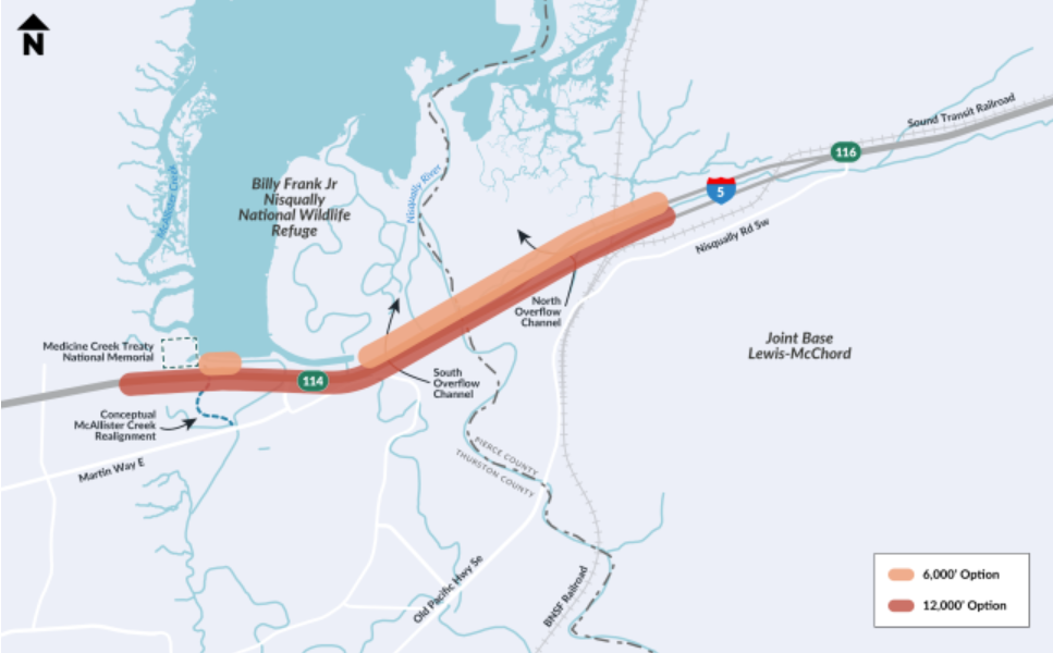
I5 Nisqually River Delta Project

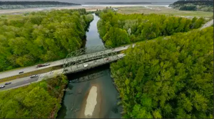
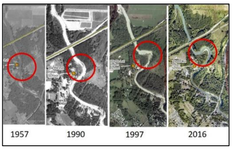
Interstate-5 (I-5) is the lifeline of commerce, transportation, and Joint Base Lewis-McChord’s (JBLM) mission readiness in the Puget Sound Region. The crossing of the Nisqually Delta represents the intersection of these critical issues and is a significant impediment to salmon recovery with direct connections to treaty rights and the plight of the Southern Resident Killer Whales (SRKW). In the South Sound this corridor is particularly important as there are no viable alternatives if disaster strikes and renders I-5 impassable, as occurred during the 2017 Amtrak derailment at DuPont. Because of these facts, the crossing of the Nisqually Delta is the most critically and strategically important stretch of I-5 in the region.

This project will:
• Reduce flooding impacts and the risk of a major event rendering this stretch impassable for transportation.

• Add much needed capacity to handle growing traffic concerns by 1) replacing the 2 river bridges and widening them from 3 to 4 lanes 2) widening I-5 from 3 to 4 lanes 3) widening the Burlington Northern railroad trestles 4) elevate I-5 across the Nisqually Delta including McAllister Creek 5) and restore critical ecological functions to increase salmon survival.

Study anticipates increased flooding due to climate change:
The study-in-progress by the US Geological Survey (USGS), funded by the Nisqually Indian Tribe and the Washington State Department of Transportation (WSDOT), finds that the I-5 corridor is being impacted by Coastal Squeeze. Coastal Squeeze refers to the changing rain and snow events in the upland areas of the Nisqually Watershed as a result of climate change interacting with the measurable and anticipated increase in sea level in Puget Sound. The study also shows the following: 

• flooding events in the Nisqually will increase in magnitude and frequency 

• overtopping of I-5 will become more regular 

• and the risk of a major natural disaster is not a matter of if but when, which appears to be as soon as 17 years in the future.

Transportation threats
The viability of the South Sound economy is dependent on transportation across this corridor. With 30% of the JBLM workforce located south of the Nisqually River, the reliable crossing of the river is critical to our national security. Additionally, WSDOT modeling shows that if nothing is done to address the bottleneck through the delta, southbound traffic will back up through Lakewood by 2040, resulting in costly delays for commerce.

Threats to salmon recovery and property
The Tribe has led an effort with multiple partners to conduct the largest estuary restoration north of San Francisco and has returned 90% of the estuary to its proper function, but it is being negatively impacted by the I-5 crossing of the delta. The current dike and fill construction of I-5 is the largest impediment to salmon recovery in the lower Nisqually Valley. The current design of I-5 blocks downstream flow of flood waters and is the cause of damage to private property in times of large floods. The backing up of flood waters can also impact tribal and trust properties. With I-5 effectively creating a dam across the Nisqually Delta, tidal water is effectively blocked and the upstream movement of salt water at high tides and is affecting sediment delivery to the newly created estuary. As sea level continues to rise, we will see changes in salinity that will negatively impact ESA-listed Chinook salmon and steelhead survival, resulting in less fish to support treaty-secured harvest by the Tribe and less food for the SRKW.

Recent threats
The Nisqually River is also taking an odd turn across from Wah-he-lut School, flowing upstream and is likely to jump its banks at a high flow and relocate east, taking out I-5 and impacting the Tribe’s property in the delta. This could impact traffic and the local economies for months while an expensive, and likely not salmon-friendly, fix is implemented.

SSMCP Advocacy and Way Ahead

What to expect

The National Environmental Policy Act environmental review process is underway. WSDOT is conducting the NEPA review as an Environmental Assessment. The purpose of an EA is to study and document the project’s potential environmental impacts. The EA will study effects related to transportation, noise and natural resources. It will also examine parks and recreation, community resources and other environmental considerations. 

WSDOT will study two scenarios in the EA: the proposed project (Build Alternative) and doing nothing (No Build Alternative).

The EA will study a 4.7 mile stretch of I-5 between Marvin Road and Mounts Road interchanges. During the EA, WSDOT will:

  • Evaluate potential design options for bridge length and other project elements.
  • Identify potential environmental impacts of the project during construction and operation.
  • Identify potential strategies to mitigate identified impacts.

The final PEL Report (PDF 4.8MB) was completed in 2023. You can find the report appendices under the History and Background tab. You can also find answers to the project’s frequently asked questions (PDF 251KB).

The primary improvements proposed with the project include:

  • Widen I-5 by adding one high-occupancy vehicle lane in each direction from approximately Marvin Road in Thurston County to Mounts Road in Pierce County.
  • Replace existing bridges and construct new bridges across the Nisqually Delta to increase the resiliency of I-5 to flooding and sea level rise and to support habitat enhancements in the delta.
  • Construct a new grade-separated crossing of the BNSF Railroad east of the Nisqually River.
  • Realign McAllister Creek where it crosses I-5 to improve tidal exchange, water quality and fish habitat.
  • Build a shared-use path adjacent to I-5, providing a nonmotorized connection between Lacey and DuPont, and improve access to the Billy Frank Jr. Nisqually National Wildlife Refuge.
  • Remove two existing fish passage barriers under I-5 in the Red Salmon Creek drainage.
  • Install new storm water treatment areas to treat runoff from I-5 within the project.
  • Improve the surrounding habitat and allow for the creation of new habitat in areas where the existing I-5 embankment would be remove.


This chart illustrates the process. WSDOT is preparing an Environmental Assessment. 

Design visualization of shared use path between southbound I-5 and Puget Sound in Nisqually.

WSDOT is studying two potential options over the Nisqually Delta. Both would replace existing Nisqually River bridges. Both realign McAllister Creek. Both would extend an elevated I-5 over the BNSF Railroad.

Maria Tobin
Program Manager
(253) 983-7804 • mtobin@cityoflakewood.us


Search this Site​

South Sound Military and Communities Partnership (SSMCP) © 2023. All Rights Reserved