JBLM North Clear Zone
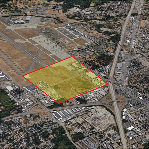
The North Clear Zone (NCZ) is a federally-designated 3,000-by 3,000-foot safety area adjacent to the north end of the McChord Field runway. It is partly within Joint Base Lewis-McChord (JBLM) and partly within the City of Lakewood. The part in Lakewood includes many light industrial business uses on privately-held properties. Based on fed[1]eral guidelines, these uses pose public and flight safety risks and are incompatible with runway operations. Some of these uses are currently allowed under Lakewood’s zoning code, and some are nonconforming uses. The businesses are valued community members and contribute to Lakewood’s economy.
Current Updates
The City of Lakewood and SSMCP have entered into a Cooperative Agreement (CA) with the US Army. This Cooperative Agreement (CA) is executed under authority of 10 U.S.C. § 2684a and 16 U.S.C. § 670c- l. There is a projected Army expenditure of up to $80M to complete this NCZ project. This CA is a cost-share agreement (80% federal / 20% local spilt) with a requirement that can include cash, land owner donations, and in-kind services. Notwithstanding the minimum, this is a best efforts agreement wherein the recipient will leverage Army funds as well as other sources of funds identified by the recipient, including State and Federal agencies, to achieve the overall funding goal. Currently, the 2020/21 focus is on the acquisition of the Tactical Tailor property.
The SSMCP and partners from the State of Washington, Pierce County, City of Lakewood, JBLM and the Department of Defense have completed work on the North Clear Zone Action and Implementation Plan (AIP). In April 2017 the City of Lakewood adopted Resolution No. 2017-09, authorizing the City to sign and execute a Memorandum of Agreement (MOA) for implementation of the AIP. In May 2017, the MOA was signed by all AIP partners. Now that the AIP is completed and the MOA is signed, the SSMCP and partners are transitioning to implementation of the AIP.
The AIP sets forth a phased strategy consisting of six actions and corresponding implementation steps designed to be carried out over the next 10-20 years to accomplish project objectives, while balancing benefits and costs among stakeholders. All of the actions are anticipated to begin in the short term (0-5 years).
AIP Actions
- Changes to City of Lakewood Code and Administrative Processes
- Amortization Study
- Voluntary Property Acquisitions and Business Relocation
- Habitat Restoration and Preservation
- Woodbrook Land Exchange
- AIP Implementation Team
Please see the NCZ project brochure below for additional information on the AIP actions and implementation phases.
About the Project
A Clear Zone is a federally-designated, 3,000-by-3,000-foot safety area adjacent to the end of a runway. This area has the highest statistical possibility of aircraft accidents. Federal Aviation Administration and Department of Defense guidelines call for Clear Zones to be undeveloped and free of people and flight obstructions. This protects the public’s safety and the military’s ability to carry out its missions.
The North Clear Zone is located at the north end of the McChord Field runway. It is partly within JBLM and partly within the City of Lakewood. The part in Lakewood includes many buildings and business on privately-held properties. Based on federal safety guidelines, these uses are incompatible with runway operations and pose public and flight safety risks. At the same time, existing businesses operating in the North Clear Zone are an important part of the local, regional and State economy.
SSMCP recently completed the JBLM Joint Land Use Study (JLUS). One of the highest priority recommendations that came out of JLUS was to develop solutions for the North Clear Zone.
“The potential for accidents is so high [in the Clear Zone] that the land use restrictions necessary to ensure compatibility would prohibit reasonable economic use of the land. Therefore, it is DOD and USAF policy to own the land within the Clear Zone, or control the land through restrictive use easements.” — Air Force Instruction (AFI)32-7063, 18 DEC 2015, para. 3-9, p 24
Project Objectives
- Ensure public and air safety
- Bring use of the North Clear Zone into Federal Aviation Administration and Department of Defense regulatory compliance
- Preserve JBLM “Mission Assurance”
- Implement the 2015 JBLM Joint Land Use Study
- Maintain full airfield operational capacity and capability
The North Clear Zone project is being conducted in four phases Phases 1-3 have been completed. They included 1) project startup, which began in summer 2017, 2) strategy analysis and cost estimates for voluntary property acquisition and business relocation, which were conducted between summer and winter 2016, and 3) development of the North Clear Zone Action Plan & Implementation Program and Memorandum of Agreement, which were finalized and adopted in spring 2017 following open houses with property owners and a Lakewood City Council study session and public comment period. The final phase, implementation, is currently underway and is anticipated to continue for the next 10-20 years. Most implementation actions will be led by project partners such as the City of Lakewood, Pierce County and JBLM. SSMCP will continue to be actively engaged, for instance by supporting formation and regular meetings of the AIP Implementation Task Force.
Project Files:
- North Clear Zone Press Release (pdf)
- McChord NCZ Brochure May 2017 (pdf)
- NCZ Property Business Owner Update (pdf)
- NCZ Open House Summary Final (pdf)
- MOA Signed (pdf)
- JBLM NCZ Final AIP (pdf)
- Send Us Your Comments on the North Clear Zone